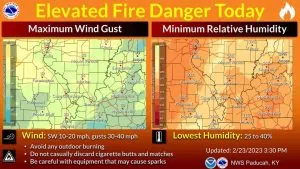
The National Weather Service reports that breezy southerly winds today (Tuesday) are ushering much warmer air into the Tri-State region. Gusts of over 30 miles per hour are expected, leading to elevated fire danger throughout the area.
A significant warming trend begins today, with temperatures climbing into the upper 40s. This unseasonable warmth will continue to intensify, with high temperatures projected to reach the low 60s by Friday and even the upper 60s on Saturday. This marks a much warmer-than-normal end to the week and start to the weekend.
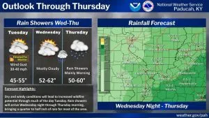
Widespread rain showers are anticipated from Wednesday night into Thursday, particularly during the morning hours. However, current forecasts suggest that rainfall amounts may not be sufficient to fully alleviate ongoing dry conditions. Another chance of rain is expected on Sunday as a new weather system approaches the region.
Residents are advised to remain cautious due to the elevated fire risk and to stay tuned for further updates from the National Weather Service.