
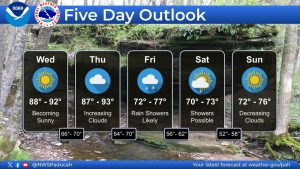
Above-normal temperatures will continue across the region through Thursday before a cold front brings cooler temperatures and rain to the area Friday.
Highs today and Thursday are expected to reach the upper 80s to lower 90s.
The cold front will move through the region Friday, bringing the best chances for showers during the morning and early afternoon. A few rumbles of thunder are possible, but severe weather is not expected.
Rainfall totals are expected to remain below one inch, with most of the precipitation moving out by Friday afternoon. That should provide drier conditions in time for Friday night high school football.
A small chance of rain will linger into Saturday as the system moves out. High pressure is then expected to build into the region Sunday, bringing dry and cooler conditions.
Weekend temperatures are forecast to be more seasonable, with highs returning to the mid-70s.