
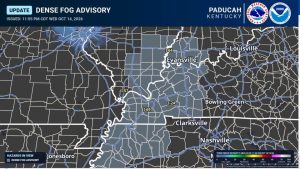
The National Weather Service in Paducah has issued a Dense Fog Advisory until 8 a.m. this (Thursday) morning for southwest Indiana, western Kentucky and portions of Southern Illinois.
Forecasters say visibility could rapidly fall to less than one-quarter mile in areas of dense fog, creating hazardous driving conditions. Motorists are urged to slow down, use low-beam headlights and allow extra distance between vehicles.
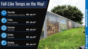
Unseasonably warm temperatures will continue today, with highs expected to reach the upper 80s to lower 90s across the region.
Shower and thunderstorm chances will increase today, especially across Southern Illinois and southwest Indiana. Some storms could become strong, with damaging wind gusts the primary concern.
A cold front will move through tonight, bringing a significant change in temperatures.
Much cooler, fall-like weather is expected tomorrow (Friday) and will continue through the weekend and into early next week. Temperatures are then expected to gradually warm again, with highs returning to the upper 70s and lower 80s by the middle of next week.