
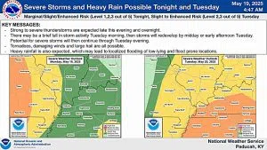
The National Weather Service (NWS) in Paducah has placed the region under a Marginal to Enhanced Risk of severe thunderstorms tonight, with a Slight to Enhanced Risk continuing into Tuesday and Tuesday evening.
Isolated to widely scattered storms are expected throughout the day today, with lightning being the primary hazard. However, storm coverage will increase tonight, and some storms may become strong to severe, bringing threats of large hail and damaging winds.
The severe weather threat intensifies on Tuesday, with a higher likelihood of severe thunderstorms, including the potential for large hail, damaging winds, and even a few tornadoes. While western Kentucky faces the greatest threat, the entire region remains at risk.
Residents are urged to stay weather aware, monitor local forecasts, and have multiple ways to receive warnings.