The National Weather Service in Paducah says Southern Illinois is enjoying a stretch of pleasant, seasonable weather, but big changes are on the way.
High pressure continues to dominate the region, keeping skies clear and conditions dry through today. Highs are expected to reach the upper 60s to lower 70s, with slightly cooler but still mild temperatures tomorrow.
However, a cold front will move through on Friday, bringing a chance for showers and thunderstorms across the area.
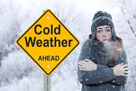
Behind the front, a dramatic cool-down is expected early next week. Forecasters say low temperatures could dip below freezing for the first time this season, with highs struggling to reach the low 40s by Monday. Morning wind chills may fall into the upper teens and lower 20s, signaling the arrival of much colder air across the region.
COLD FRONT TO BRING RAIN FRIDAY, FIRST FREEZE EXPECTED EARLY NEXT WEEK
Nov 6, 2025 | 6:01 AM