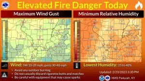
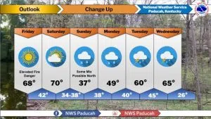
The National Weather Service has issued a warning for elevated wildfire and brush fire risk today, as relative humidity levels are expected to drop to between 20 and 30 percent. Southwest winds of 10 to 15 mph, combined with ongoing very dry conditions, increase the potential for rapid wildfire growth and spread. Residents are urged to exercise extra caution and avoid any activities that could spark fires.
Dry and mild weather will persist through Saturday, with temperatures running 10 to 15 degrees above average. Sunny skies are expected today, with warmer temperatures forecast for today and Saturday—reaching the upper 60s and low 70s across the Ohio Valley.
A shift in the weather pattern arrives Sunday, bringing a chance of light rain that will last into early next week. Temperatures will cool off, dropping to the upper 40s on Sunday and the low 40s on Monday, before rebounding to around 50 degrees by Tuesday and Wednesday.
Meteorologists are also monitoring a push of cold air from the north, which could bring accumulating winter precipitation along the Interstate 64 corridor, particularly in northern counties. However, the current outlook favors a generally warmer and wetter system early next week. The situation will continue to be monitored for any potential impacts from winter weather.