
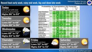
Near-record to record warmth is expected across the region through Tuesday before a major change in the weather pattern later this week.
The National Weather Service in Paducah says high temperatures today and Tuesday are expected to reach the upper 80s to lower 90s, well above normal for mid-October. Overnight lows will remain in the 60s, and record high and record warm low temperatures could be challenged.
Rain chances will begin increasing late Tuesday night, with showers and some thunderstorms possible Wednesday through Thursday night as a cold front moves across the area.
Behind the front, much cooler and breezier weather will arrive Friday. Northerly winds could gust to around 30 mph.
By Saturday, temperatures are expected to be well below normal, with highs only in the 60s and overnight lows falling into the 30s.
The National Weather Service says the sharp change will mark a return to much more fall-like conditions heading into the weekend.