
Southern Illinois residents can expect a warm Veterans Day followed by showers and thunderstorms Wednesday afternoon and evening, before a significant cooldown brings freezing temperatures to the region this weekend.
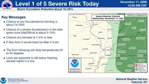
According to the National Weather Service in Paducah, temperatures today (Wednesday) will climb to around 70 degrees before showers and thunderstorms move through the area.
While the overall threat of severe weather remains exceptionally low, forecasters say a few storms could become strong. If a storm reaches severe levels, damaging wind gusts would be the primary concern. A brief, weak tornado cannot be completely ruled out if a rotating thunderstorm develops.
However, meteorologists emphasize that the severe weather threat is highly conditional, meaning even a small change in atmospheric conditions could eliminate the risk altogether.
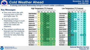
Much cooler weather arrives Thursday, with morning temperatures in the middle 40s and afternoon highs only reaching the middle 50s. Mostly cloudy skies and a slight chance of light showers are expected.
Temperatures will fall into the middle 30s Thursday night, with Friday afternoon struggling to climb out of the 40s.
The coldest weather is expected over the weekend. Both Saturday and Sunday mornings could see widespread temperatures in the 20s, with a hard freeze possible across portions of Southern Illinois.
Saturday afternoon temperatures will remain around or below 50 degrees, with Sunday warming slightly.
Temperatures will begin to moderate early next week. Morning lows Monday and Tuesday are expected to be near or slightly above freezing, while afternoon highs return to the middle 50s, which is near normal for mid-November.
Residents are encouraged to monitor the latest forecasts for any changes in today’s weather and prepare for freezing conditions this weekend.